In a lab tucked into the back of the Nguyen Engineering Building on the George Mason campus, a group of undergrads, grads, and PhD candidates from a wide range of disciplines — engineering, geography, and computer science — tackle a joint effort and shared passion: Flood Hazards Research.
 Welcome to “SurgeNOW: Enabling real-time weather coastal flooding forecasts in the Chesapeake Bay.”
Welcome to the Mason Flood Hazards Research Lab and Team Ferreira.
This 4–VA funded project team, led by Associate Professor in Water Resources Engineering Dr. Celso Ferreira, is working in collaboration to create a pioneering system to predict floods and create flood threat alerts in real-time throughout the Chesapeake Bay region.
Water Power: A Personal, Professional, and Property Takeaway
Brazilian-native Ferreira initially became interested in the flow of water as a surfer growing up near the coast of the Atlantic. However, his focus on water flow grew by several chance turns in his career path — the first when he arrived at Texas A & M University as Hurricane Ike slammed through Galveston in 2008; and again in 2012 when Hurricane Sandy hit the East Coast shortly after he began his career at Mason. Those fateful encounters offered Ferreira a front row seat to the powerful effects of nature’s greatest resource.
“In addition to loss of life, flooding can have devastating economic consequences,” explains Ferreira. “Superstorm Sandy caused an estimated $50 billion in damage, and more recently, Hurricane Matthew resulted in extensive flooding throughout Virginia. Understanding more about flood waters is critically important for the Commonwealth.”
The Necessary Science
Ferreira’s vision to revolutionize the way citizens along the Chesapeake Bay receive essential flood alert warnings necessitates that a variety of elements be brought to bear on his project, including:
- Amalgamation of numerical models for hindcasting and forecasting storm surges which consider the complex interactions between massive weather systems, mesoscale and sub-mesoscale ocean process, river discharges, estuaries response, high frequency tidal oscillations, flow over wetlands and the complex hydrodynamics in coastal areas.
- Integration of existing radar networks, hydrodynamic and wave models, climate models, tropical storm wind and pressure parametric models, tidal databases, and river discharge data.
- Utilization of critical expertise developed by Dr. Jen Irish at partner school Virginia Tech to determine probabilistic maximum hurricane surge forecasts based on surge response functions, available meteorological information, and joint probability statistics.
- Incorporation of a smart mesh network to collect data from Mason’s five existing field site stations at coastal and emergent areas in the Chesapeake Bay which monitor water levels, current velocities, wave spectra and atmospheric variables. (Currently, data from these sites is collected via periodical travel to the sites hundreds of miles away from each other for retrieving and downloading.)
- Development of a geographical information system framework based on a data model developed at Mason known as Arc StormSurge which converts outputs for tropical storm inundation maps to predict impacted areas and provide validation for the modeling framework. This interface will also offer a public access interface to provide evidence on storm surge simulations for a specific area.
Once these important elements are in place, Ferreira explains that a critical component of the project is the development of Internet of Things (IoT) mobile sensors. Through these sensors, to be deployed in recreational boats scattered throughout the Chesapeake, statistics on water flow can be collected and disseminated in real time, providing data critical to predicting storm surges. “Through hundreds of monitors throughout the Bay, rather than a single or a scattered few portals, we will essentially be employing crowd-sourced and resourced information,” notes Ferreira.
“Using IoT technology opens this project up to millions of data collection points and provides not only scientists, but residents of the Chesapeake Bay, the opportunity to get valuable life-saving indicators that can protect people and property,” adds Ferreira.
At the crux of the IoT challenge is the development of a sensor that is both reliable and affordable with the second requirement being paramount to the execution of the project. “To truly capture the crowd-sourced element of this effort, it is imperative that the sensors be reasonably priced for widespread dissemination,” says Ferreira. “Currently, the sensors we use can range from $5,000 to $10,000. Naturally that’s not a feasible price tag if we want to cover the Bay.” Ferreira’s goal is to produce a sensor for no more than $200.
Team Players
Currently, building and refining that sensor currently falls squarely in the lap of senior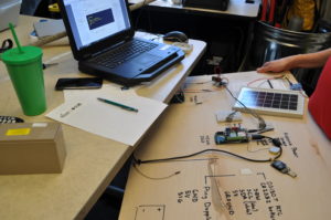 engineering student Dan Bentley. We find Dan in the lab, balancing before him a plywood board mounted with various components of said sensor — including a battery, solar panel, satellite modem and microcontroller. Dan understands the value and importance of the data being collected and relayed, explaining, “The data that the sensors will monitor and send to the cloud or through a cellular network will be vital to the project. These sensors must be accurate and dependable.”
 Across from Bentley sits Prakriti Khanal, an engineering major who is knee deep in research on tides when the conversation in the lab turns to the group’s last trip to the field site stations on the Bay. They discuss the various responsibilities for each team member and results of the outing, with Prakriti duly noting that every trip begins with one important first stop. “We head to Wawa and get coffee!” she laughs.
Two of the students in the lab that day are looking not at the water, but more specifically at the land that the water may impact.
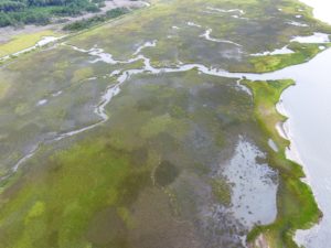
Thanks to the digital maps in development by project member and geography major Tirik Ford, the group can calculate the results of coastal flooding on the landforms lining the waters of the Chesapeake. Tirik is working on refining his elevation map of the land surrounding Magothy Bay — sharing the information with the others in the room.
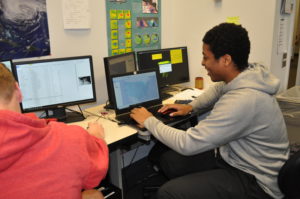
Farther up the bank of computers in the lab is Selina Jahan Sumi, a PhD candidate with a focus on Water Resources Engineering. Selina is busy integrating data from both the National Oceanic and Atmospheric Administration and United States Geological Survey into her maps. She is taking a deep look at how flooding might affect the landforms near the upper Potomac River and the sixth most populated metropolitan area in the U.S. – Washington, DC.
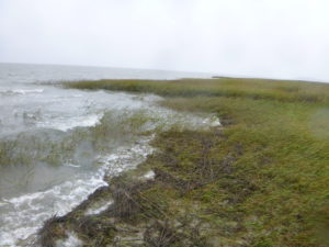
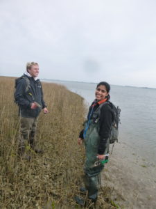
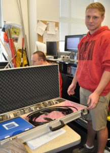 The conversation then circles back to trips to the field stations. That’s when Tyler Miesse pulls out some of the equipment they bring to the stations, and pulls up some photos from the team’s recent trip to the Magothy Bay station. Pictured are lab team members with various instruments to measure the water level and assess water flow in the marsh. Tyler, who was raised Virginia Beach, and who shares a love of surfing with Ferreira, is acutely interested the role of the marshes during extreme storm events. “The salt marshes are critically important to the life of the Bay,” he notes. “The vegetation within the marsh efficiently weakens and reduces the waves during storm surges, and provides a key defense for the land.”
Ferreira notes, however, that the “SurgeNOW” effort goes well beyond the lab partners we meet today. “This 4-VA grant allowed us to pull a wide range of people and resources together — Arslaan Khalid, an Engineering major who developed a prototype system on “Poseidon” our supercomputing cluster; Thomas Jefferson High School for Science and Technology student Pavani Ravella who transitioned our system from one from one platform to another; and of course, Seth Lawler, a Master’s student that helped launch the thought process thanks to the boat he keeps on the Chesapeake!”
It’s a team project that will return important results for the Chesapeake Bay community.